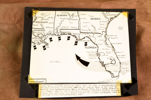


Original 1947 AP Wire Photo map dated September 18 showing a hurricane moving into the Gulf of Mexico after crossing southern Florida near Fort Myers and veering northwest. According to the caption, hurricane warnings were issued along a roughly 500-mile stretch of Gulf Coast from Apalachicola, Florida, to Morgan City, Louisiana. Flag symbols mark the warning area while a large arrow shows the storm's projected movement. The caption is separate from the photograph, and both are mounted on the same piece of black archival paper. Measures approximately 9¼ x 8 inches. From the archive of a Pittsburgh-area newspaper.